Scientists start drilling into the "Noah's Ark" site: radar points to right-angled voids beneath a 538-foot formation near Mount Ararat
A Turkish and American team spent 90 days at the hull-shaped formation, collected 1,000 soil samples and found pottery. The lab results are still to come.
Not yet confirmedUnder investigation. Here is what is known and what still needs proof.
Since 1959, a boat-shaped formation of earth and rock in eastern Turkey has fed hopes that the remains of Noah's ark lie inside it. This year it is back in the news: a team led by Professor Cenker Atila of Sivas Cumhuriyet University spent about 90 days at the site and, in late September, began drilling into it. So far, no laboratory results have been published.
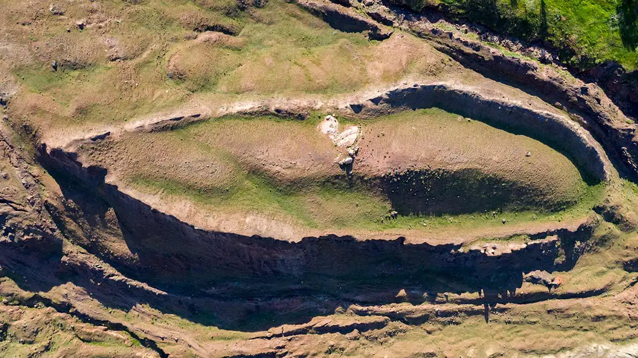
The site is called Durupınar. It lies near the village of Üzengili, in the Doğubayazıt district, 18 miles south of the summit of Mount Ararat and a few miles from the Iranian border. It is about 538 feet long. That number gets attention because Genesis 6:15 gives the ark a length of 300 cubits, roughly 515 feet depending on the cubit used. To understand what's at stake, it helps to know the site's history, what the Bible actually says, and what science would need to see before calling anything a discovery.
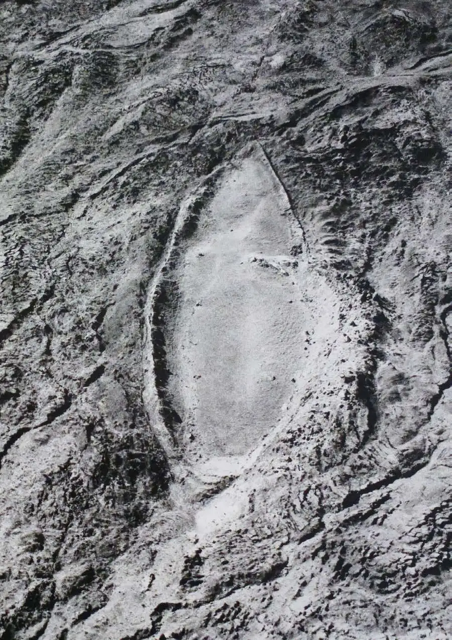
The formation was noticed in 1959 by a Turkish army captain, İlhan Durupınar, while he was studying aerial photographs taken to map the region. He saw a pointed oval outline, like a hull, in a field of mud and stone at nearly 6,500 feet. In 1960, Life magazine published the photo, and that same year a Turkish and American expedition went to the site. The team dug and examined it for two days, found only earth and rock, and concluded it was a quirk of nature.
The story revived in 1977 with Ron Wyatt, an American nurse anesthetist and amateur archaeologist who visited the site many times and claimed to have found petrified wood, metal rivets and stone anchors. None of those claims was accepted by professional geologists or archaeologists. Interest grew anyway, and in 1987 the Turkish government declared the area a national park and built a visitor center on a hill facing the formation.
What the 2026 team found
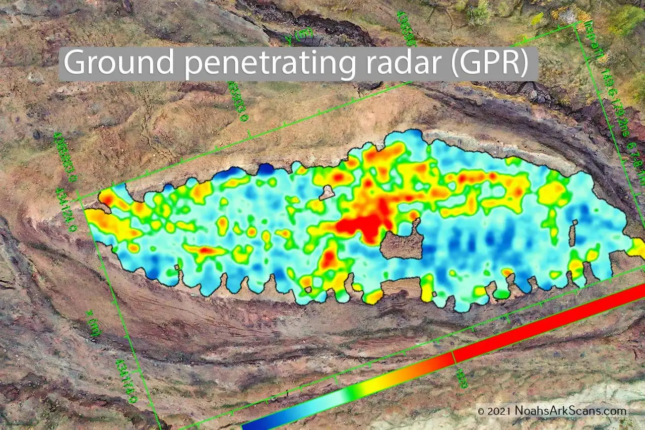
According to Greek City Times, this year's season collected about 1,000 soil samples from 150 locations and sent them to Ankara to look for organic matter and traces of wood. Ground-penetrating radar used in August picked up voids and anomalies with fairly regular edges, some at right angles, which the team reads as possible compartments. Pottery fragments also turned up, not yet dated. Results are expected over the winter of 2026-27, and the university plans to publish a report on the first season.
The drilling is being done with Noah's Ark Scans, an American group that uses a small excavation robot designed by Robert Ross of La Trobe University in Australia, according to a second report from the same outlet. The group raises donations for the expedition, which is a good reason to read its own announcements with care.
Why radar and pottery don't prove anything yet
Each of these clues has well-known limits. Ground-penetrating radar sends waves below the surface and records where they bounce back. Changes in moisture, clay layers, rock fractures and loose boulders all produce reflections, and straight lines can come from natural processes. A radar image tells you where to dig, not what is down there.
Ground-penetrating radar readings laid over a drone photo of the formation, released by the group in 2021. The colors show where the signal bounced back strongest, not what lies underneath. Photo: Prof. Dr. Cenker Atila / Project Director
Pottery shows human presence, but the Doğubayazıt area has been inhabited for thousands of years, along an ancient route between Anatolia and Iran. Shards can be dated by style or by thermoluminescence, a method that measures when the clay was last heated. Even a very old date would tell us when someone made a pot, not that it came from a boat.
The soil samples are the most promising part, because wood, if there is any, can be radiocarbon dated. The test measures the radioactive carbon a living thing stops absorbing when it dies, and it works on material up to about 50,000 years old. But the history of ark hunting carries a warning. In 1955, French explorer Fernand Navarra brought down a piece of worked timber from the ice of Mount Ararat and presented it as part of the ark. Later radiocarbon tests placed it in the seventh or eighth century A.D., most likely the remains of a chapel or a pilgrims' shelter.
What geologists say
Durupınar has been examined many times, and the findings point the same way. In 1996, geologist Lorence Collins and David Fasold published a study concluding that the formation is natural: a fold of rock surrounded by mudflow material, shaped into a hull-like outline by erosion. Fasold's case is striking. Years earlier he had written a book arguing that the site was the ark, and he changed his mind after studying the rocks.
A 2025 report by Turkish geologist Eşref Atabey of the country's mineral research agency reached the same conclusion. Even creationist geologist Andrew Snelling, who defends the historicity of the flood, considers the formation natural. In January, geographer Faruk Kaya, vice rector of Ağrı İbrahim Çeçen University, told Christian Today that pottery shards found near the formation during road work may point to ancient human activity in the area but are not evidence of any link to the ark.
What the Bible says about the place
Genesis 8:4 says that in the seventh month, on the seventeenth day, the ark came to rest "on the mountains of Ararat," plural. Ararat was not the name of a single mountain but of a region: the ancient kingdom of Urartu, which flourished from the ninth to the sixth century B.C. around Lake Van and stretched across what is now eastern Turkey, Armenia and northwestern Iran. The Bible uses the name that way elsewhere. After killing the Assyrian king Sennacherib, his sons fled "into the land of Ararat" (2 Kings 19:37), and Jeremiah summons "the kingdoms of Ararat" against Babylon (Jeremiah 51:27).
The peak now called Mount Ararat, at 16,854 feet the highest in Turkey, got that name much later. The biblical text doesn't point to a specific summit, so tradition has never spoken with one voice. Syriac Christians and Islamic tradition place the ark's landing on Mount Judi, near the Syrian and Iraqi borders, roughly 190 miles to the south. Josephus himself, in the first century, quotes the Babylonian historian Berossus as saying remains of the vessel could still be seen in Armenia, in the mountains of the Cordyaeans, where people scraped off bitumen to use as amulets.
Other searches have come up empty too. In 2010, an evangelical group from Hong Kong announced it had found wooden compartments at about 13,000 feet on Mount Ararat. The photos were never examined by independent experts, and others involved in the search raised serious doubts about where the material came from.
How to follow the story from here
For Durupınar to move from possibility to discovery, a few steps are essential. Dating has to be done by recognized laboratories and published with the data so others can check it. The radar anomalies have to be excavated and described. And the results have to go through peer-reviewed journals, with review by specialists from outside the expedition, including geologists who know the formation.
For Bible readers, this calls for patience rather than anxiety. The story of Noah doesn't depend on wood found in Turkey, and the Christian faith never has. Genesis tells a story of judgment, mercy and a new beginning, and Peter uses the ark as a picture of salvation (1 Peter 3:20-21). If solid evidence ever surfaces, it will deserve attention. Until then, the honest thing is to say what is known and what is still missing.